Index of /pub/wp-content/uploads/2015/12
Name
Last modified
Size
Description
Parent Directory
-
Bridgnorth-Sandstone-page-16-150x110.jpg
2015-12-11 12:21
11K
Bridgnorth-Sandstone-page-16-150x150.jpg
2015-12-11 12:21
14K
Bridgnorth-Sandstone-page-16-300x219.jpg
2015-12-11 12:21
36K
Bridgnorth-Sandstone-page-16-400x293.jpg
2015-12-11 12:21
56K
Bridgnorth-Sandstone-page-16.jpg
2015-12-11 12:21
245K
Tank-Quarry-150x100.jpg
2015-12-16 10:13
7.9K
Tank-Quarry-150x150.jpg
2015-12-16 10:13
11K
Tank-Quarry-300x200.jpg
2015-12-16 10:13
27K
Tank-Quarry-400x267.jpg
2015-12-16 10:13
45K
Tank-Quarry.jpg
2015-12-16 10:13
219K
Geological-Sites-in-the-Abberley-and-Malvern-Hills-Geopark.xlsx
2015-12-16 11:20
15K
wainlode-72x150.jpg
2015-12-16 14:33
4.4K
wainlode-143x300.jpg
2015-12-16 14:33
14K
wainlode-150x150.jpg
2015-12-16 14:33
6.4K
wainlode-400x839.jpg
2015-12-16 14:33
77K
wainlode.jpg
2015-12-16 14:33
189K
section-6.12-Shavers-end-quarry.-G.R-7695-6763.-GW-site-location-no.-25.-EHT-1-150x150.jpg
2015-12-16 15:02
8.1K
section-6.12-Shavers-end-quarry.-G.R-7695-6763.-GW-site-location-no.-25.-EHT-1-300x225.jpg
2015-12-16 15:02
22K
section-6.12-Shavers-end-quarry.-G.R-7695-6763.-GW-site-location-no.-25.-EHT-1.jpg
2015-12-16 15:02
911K
section-6.12-Shavers-end-quarry.-G.R-7695-6763.-GW-site-location-no.-25.-EHT-1-150x113.jpg
2015-12-16 15:02
6.6K
section-6.12-Shavers-end-quarry.-G.R-7695-6763.-GW-site-location-no.-25.-EHT-1-400x300.jpg
2015-12-16 15:02
36K
section-6.12-Shavers-end-quarry.-G.R-7695-6763.-GW-site-location-no.-25.-EHT-1-1024x768.jpg
2015-12-16 15:02
197K
section-6.13-views-from-Abberley-Hil.-EHT-1-modified-150x150.jpg
2015-12-16 15:02
7.0K
section-6.13-views-from-Abberley-Hil.-EHT-1-modified.jpg
2015-12-16 15:02
931K
section-6.13-views-from-Abberley-Hil.-EHT-1-modified-300x95.jpg
2015-12-16 15:02
9.2K
section-6.13-views-from-Abberley-Hil.-EHT-1-modified-1024x325.jpg
2015-12-16 15:02
89K
section-6.13-views-from-Abberley-Hil.-EHT-1-modified-150x48.jpg
2015-12-16 15:02
3.0K
section-6.13-views-from-Abberley-Hil.-EHT-1-modified-400x127.jpg
2015-12-16 15:02
15K
section-6.7-exposure-on-west-side-of-sunken-lane.-parrallel-staright-beds.-G.R-7887-6735.-GW-site-location-no.-24-150x150.jpg
2015-12-16 16:23
11K
section-6.7-exposure-on-west-side-of-sunken-lane.-parrallel-staright-beds.-G.R-7887-6735.-GW-site-location-no.-24.jpg
2015-12-16 16:23
206K
section-6.7-exposure-on-west-side-of-sunken-lane.-parrallel-staright-beds.-G.R-7887-6735.-GW-site-location-no.-24-150x113.jpg
2015-12-16 16:23
8.8K
section-6.7-exposure-on-west-side-of-sunken-lane.-parrallel-staright-beds.-G.R-7887-6735.-GW-site-location-no.-24-300x225.jpg
2015-12-16 16:23
31K
section-6.7-exposure-on-west-side-of-sunken-lane.-parrallel-staright-beds.-G.R-7887-6735.-GW-site-location-no.-24-400x300.jpg
2015-12-16 16:23
52K
Gneissose-foliation-in-Chase-end-Quarry-150x115.jpg
2015-12-16 16:36
9.8K
Gneissose-foliation-in-Chase-end-Quarry-150x150.jpg
2015-12-16 16:36
12K
Gneissose-foliation-in-Chase-end-Quarry-300x229.jpg
2015-12-16 16:36
35K
Gneissose-foliation-in-Chase-end-Quarry.jpg
2015-12-16 16:36
172K
Gneissose-foliation-in-Chase-end-Quarry-400x306.jpg
2015-12-16 16:36
59K
Photo-2.-Clutters-cave-12-Feb-2009-150x113.jpg
2015-12-16 16:52
8.1K
Photo-2.-Clutters-cave-12-Feb-2009-150x150.jpg
2015-12-16 16:52
9.6K
Photo-2.-Clutters-cave-12-Feb-2009-300x225.jpg
2015-12-16 16:52
27K
Photo-2.-Clutters-cave-12-Feb-2009-400x300.jpg
2015-12-16 16:52
43K
Photo-2.-Clutters-cave-12-Feb-2009.jpg
2015-12-16 16:52
76K
Dog-Hill-Wood-Ledbury-4-150x113.jpg
2015-12-16 17:03
11K
Dog-Hill-Wood-Ledbury-4-150x150.jpg
2015-12-16 17:03
14K
Dog-Hill-Wood-Ledbury-4-300x225.jpg
2015-12-16 17:03
39K
Dog-Hill-Wood-Ledbury-4-400x300.jpg
2015-12-16 17:03
67K
Dog-Hill-Wood-Ledbury-4.jpg
2015-12-16 17:03
160K
Malvern-Hills.-View-north-over-north-Hill-and-beyond-towards-the-Abberley-Hills-ridge-line-150x113.jpg
2015-12-16 17:26
6.7K
Malvern-Hills.-View-north-over-north-Hill-and-beyond-towards-the-Abberley-Hills-ridge-line-150x150.jpg
2015-12-16 17:26
8.4K
Malvern-Hills.-View-north-over-north-Hill-and-beyond-towards-the-Abberley-Hills-ridge-line-300x225.jpg
2015-12-16 17:26
23K
Malvern-Hills.-View-north-over-north-Hill-and-beyond-towards-the-Abberley-Hills-ridge-line-400x300.jpg
2015-12-16 17:26
39K
Malvern-Hills.-View-north-over-north-Hill-and-beyond-towards-the-Abberley-Hills-ridge-line.jpg
2015-12-16 17:26
299K
Gullet-quarry-20th-June-2010-5-150x113.jpg
2015-12-16 17:38
8.4K
Gullet-quarry-20th-June-2010-5-150x150.jpg
2015-12-16 17:38
10K
Gullet-quarry-20th-June-2010-5-300x225.jpg
2015-12-16 17:38
28K
Gullet-quarry-20th-June-2010-5-400x300.jpg
2015-12-16 17:38
47K
Gullet-quarry-20th-June-2010-5.jpg
2015-12-16 17:38
84K
19663727-150x94.jpg
2015-12-16 17:49
5.3K
19663727-150x150.jpg
2015-12-16 17:49
7.4K
19663727-300x188.jpg
2015-12-16 17:49
17K
19663727-400x250.jpg
2015-12-16 17:49
28K
19663727.jpg
2015-12-16 17:49
146K
GR727933.-Hermiatge-hill-coppice-lookout-exposure-416th-March-2007-150x113.jpg
2015-12-16 18:04
7.3K
GR727933.-Hermiatge-hill-coppice-lookout-exposure-416th-March-2007-150x150.jpg
2015-12-16 18:04
9.4K
GR727933.-Hermiatge-hill-coppice-lookout-exposure-416th-March-2007-300x225.jpg
2015-12-16 18:04
25K
GR727933.-Hermiatge-hill-coppice-lookout-exposure-416th-March-2007-400x300.jpg
2015-12-16 18:04
41K
GR727933.-Hermiatge-hill-coppice-lookout-exposure-416th-March-2007.jpg
2015-12-16 18:04
75K
Hobbs-quarry-Longhope-150x113.jpg
2015-12-16 18:12
8.0K
Hobbs-quarry-Longhope-150x150.jpg
2015-12-16 18:12
11K
Hobbs-quarry-Longhope-300x225.jpg
2015-12-16 18:12
30K
Hobbs-quarry-Longhope-400x300.jpg
2015-12-16 18:12
52K
Hobbs-quarry-Longhope.jpg
2015-12-16 18:12
186K
huntquarry-150x113.jpg
2015-12-16 18:24
8.9K
huntquarry-150x150.jpg
2015-12-16 18:24
12K
huntquarry-300x225.jpg
2015-12-16 18:24
32K
huntquarry-400x300.jpg
2015-12-16 18:24
54K
huntquarry.jpg
2015-12-16 18:24
137K
Ivy-Scar-Rock-Malvern-Hills-150x113.jpg
2015-12-16 18:29
9.6K
Ivy-Scar-Rock-Malvern-Hills-150x150.jpg
2015-12-16 18:29
12K
Ivy-Scar-Rock-Malvern-Hills-300x225.jpg
2015-12-16 18:29
33K
Ivy-Scar-Rock-Malvern-Hills-400x300.jpg
2015-12-16 18:29
54K
Ivy-Scar-Rock-Malvern-Hills.jpg
2015-12-16 18:29
106K
Knapp-and-Papermill-Leigh-brook-150x113.jpg
2015-12-16 18:38
8.9K
Knapp-and-Papermill-Leigh-brook-150x150.jpg
2015-12-16 18:38
12K
Knapp-and-Papermill-Leigh-brook-300x225.jpg
2015-12-16 18:38
32K
Knapp-and-Papermill-Leigh-brook-400x300.jpg
2015-12-16 18:38
53K
Knapp-and-Papermill-Leigh-brook.jpg
2015-12-16 18:38
176K
Lavingtons-cave-Bridgnorth-150x113.jpg
2015-12-16 18:44
8.7K
Lavingtons-cave-Bridgnorth-150x150.jpg
2015-12-16 18:44
11K
Lavingtons-cave-Bridgnorth-300x225.jpg
2015-12-16 18:44
30K
Lavingtons-cave-Bridgnorth.jpg
2015-12-16 18:44
191K
Lavingtons-cave-Bridgnorth-400x300.jpg
2015-12-16 18:44
49K
Leapgate-railway-line-nr-Wilden-top-rd-bridge-150x113.jpg
2015-12-16 21:11
8.5K
Leapgate-railway-line-nr-Wilden-top-rd-bridge-150x150.jpg
2015-12-16 21:11
11K
Leapgate-railway-line-nr-Wilden-top-rd-bridge-300x225.jpg
2015-12-16 21:11
32K
Leapgate-railway-line-nr-Wilden-top-rd-bridge-400x300.jpg
2015-12-16 21:11
55K
Leapgate-railway-line-nr-Wilden-top-rd-bridge.jpg
2015-12-16 21:11
261K
Mathon-150x100.jpg
2015-12-16 21:17
4.9K
Mathon-150x150.jpg
2015-12-16 21:17
6.1K
Mathon-300x200.jpg
2015-12-16 21:17
15K
Mathon-400x267.jpg
2015-12-16 21:17
25K
Mathon.jpg
2015-12-16 21:17
138K
may-hill-view-to-the-horseshoe-bend-of-the-river-severn-which-marks-teh-southern-most-extent-of-the-AMHG.jpg
2015-12-16 21:25
1.5M
may-hill-view-to-the-horseshoe-bend-of-the-river-severn-which-marks-teh-southern-most-extent-of-the-AMHG-150x150.jpg
2015-12-16 21:25
6.8K
may-hill-view-to-the-horseshoe-bend-of-the-river-severn-which-marks-teh-southern-most-extent-of-the-AMHG-300x225.jpg
2015-12-16 21:25
19K
may-hill-view-to-the-horseshoe-bend-of-the-river-severn-which-marks-teh-southern-most-extent-of-the-AMHG-1024x768.jpg
2015-12-16 21:25
180K
may-hill-view-to-the-horseshoe-bend-of-the-river-severn-which-marks-teh-southern-most-extent-of-the-AMHG-150x113.jpg
2015-12-16 21:25
5.6K
may-hill-view-to-the-horseshoe-bend-of-the-river-severn-which-marks-teh-southern-most-extent-of-the-AMHG-400x300.jpg
2015-12-16 21:25
31K
section-5.15-redstone-rock-G.R-814699.-GW-site-location-no.-22-1-150x113.jpg
2015-12-16 21:49
6.6K
section-5.15-redstone-rock-G.R-814699.-GW-site-location-no.-22-1-150x150.jpg
2015-12-16 21:49
8.2K
section-5.15-redstone-rock-G.R-814699.-GW-site-location-no.-22-1-300x225.jpg
2015-12-16 21:49
23K
section-5.15-redstone-rock-G.R-814699.-GW-site-location-no.-22-1-400x300.jpg
2015-12-16 21:49
40K
section-5.15-redstone-rock-G.R-814699.-GW-site-location-no.-22-1.jpg
2015-12-16 21:49
128K
section-4b.7-exp-G.R-747-764.-GW-site-location-no.-14-5-150x113.jpg
2015-12-16 21:53
8.6K
section-4b.7-exp-G.R-747-764.-GW-site-location-no.-14-5-150x150.jpg
2015-12-16 21:53
11K
section-4b.7-exp-G.R-747-764.-GW-site-location-no.-14-5-300x225.jpg
2015-12-16 21:53
30K
section-4b.7-exp-G.R-747-764.-GW-site-location-no.-14-5-400x300.jpg
2015-12-16 21:53
50K
section-4b.7-exp-G.R-747-764.-GW-site-location-no.-14-5.jpg
2015-12-16 21:53
217K
12188991_1650051708601502_4554455385388244737_n-113x150.jpg
2015-12-16 21:59
8.7K
12188991_1650051708601502_4554455385388244737_n-150x150.jpg
2015-12-16 21:59
11K
12188991_1650051708601502_4554455385388244737_n-225x300.jpg
2015-12-16 21:59
31K
12188991_1650051708601502_4554455385388244737_n-400x533.jpg
2015-12-16 21:59
86K
12188991_1650051708601502_4554455385388244737_n.jpg
2015-12-16 21:59
83K
The-Canyon-near-Penny-Hill-Quarry-150x113.jpg
2015-12-17 08:41
9.3K
The-Canyon-near-Penny-Hill-Quarry-150x150.jpg
2015-12-17 08:41
12K
The-Canyon-near-Penny-Hill-Quarry-300x225.jpg
2015-12-17 08:41
34K
The-Canyon-near-Penny-Hill-Quarry-400x300.jpg
2015-12-17 08:41
57K
The-Canyon-near-Penny-Hill-Quarry.jpg
2015-12-17 08:41
76K
River-Teme-Martley-150x113.jpg
2015-12-17 08:51
5.2K
River-Teme-Martley-150x150.jpg
2015-12-17 08:51
6.4K
River-Teme-Martley-300x225.jpg
2015-12-17 08:51
17K
River-Teme-Martley-400x300.jpg
2015-12-17 08:51
29K
River-Teme-Martley.jpg
2015-12-17 08:51
147K
GR-746625.-Veiw-looking-NNW-from-footpath-signpost-1.-6th-March-07-150x113.jpg
2015-12-17 09:29
5.7K
GR-746625.-Veiw-looking-NNW-from-footpath-signpost-1.-6th-March-07-150x150.jpg
2015-12-17 09:29
6.9K
GR-746625.-Veiw-looking-NNW-from-footpath-signpost-1.-6th-March-07-300x225.jpg
2015-12-17 09:29
19K
GR-746625.-Veiw-looking-NNW-from-footpath-signpost-1.-6th-March-07-400x300.jpg
2015-12-17 09:29
32K
GR-746625.-Veiw-looking-NNW-from-footpath-signpost-1.-6th-March-07.jpg
2015-12-17 09:29
144K
triassic-mercia-mudstone-and-penarth-groups-garden-cliffsevern-estuary2-150x113.jpg
2015-12-17 09:41
7.1K
triassic-mercia-mudstone-and-penarth-groups-garden-cliffsevern-estuary2-150x150.jpg
2015-12-17 09:41
9.0K
triassic-mercia-mudstone-and-penarth-groups-garden-cliffsevern-estuary2-300x225.jpg
2015-12-17 09:41
24K
triassic-mercia-mudstone-and-penarth-groups-garden-cliffsevern-estuary2-400x300.jpg
2015-12-17 09:41
39K
triassic-mercia-mudstone-and-penarth-groups-garden-cliffsevern-estuary2.jpg
2015-12-17 09:41
166K
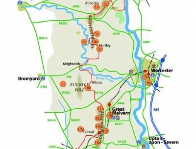
Trails-in-the-southern-section-map-2015-150x150.jpg
2015-12-19 07:58
9.0K
Trails-in-the-southern-section-map-2015-300x272.jpg
2015-12-19 07:58
23K
Trails-in-the-southern-section-map-2015.jpg
2015-12-19 07:58
912K
Trails-in-the-southern-section-map-2015-150x136.jpg
2015-12-19 07:58
7.8K
Trails-in-the-southern-section-map-2015-400x363.jpg
2015-12-19 07:58
36K
Trails-in-the-southern-section-map-2015-1024x929.jpg
2015-12-19 07:58
138K
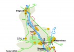
Trails-in-the-central-section-map-2015-150x114.jpg
2015-12-19 07:58
7.7K
Trails-in-the-central-section-map-2015-150x150.jpg
2015-12-19 07:58
12K
Trails-in-the-central-section-map-2015-300x228.jpg
2015-12-19 07:58
24K
Trails-in-the-central-section-map-2015-1024x778.jpg
2015-12-19 07:58
145K
Trails-in-the-central-section-map-2015.jpg
2015-12-19 07:58
1.0M
Trails-in-the-central-section-map-2015-400x304.jpg
2015-12-19 07:58
37K
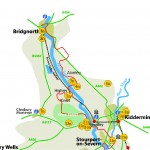
Trails-in-the-northern-section-map-2015-150x105.jpg
2015-12-19 07:59
5.0K
Trails-in-the-northern-section-map-2015-150x150.jpg
2015-12-19 07:59
8.4K
Trails-in-the-northern-section-map-2015-300x209.jpg
2015-12-19 07:59
14K
Trails-in-the-northern-section-map-2015-1024x713.jpg
2015-12-19 07:59
94K
Trails-in-the-northern-section-map-2015.jpg
2015-12-19 07:59
618K
Trails-in-the-northern-section-map-2015-400x279.jpg
2015-12-19 07:59
23K
f5c00fe5a6c6f2f5720779d5f911b432-150x98.jpg
2015-12-19 12:18
8.2K
f5c00fe5a6c6f2f5720779d5f911b432-150x150.jpg
2015-12-19 12:18
12K
f5c00fe5a6c6f2f5720779d5f911b432-300x196.jpg
2015-12-19 12:18
27K
f5c00fe5a6c6f2f5720779d5f911b432-400x261.jpg
2015-12-19 12:18
44K
f5c00fe5a6c6f2f5720779d5f911b432.jpg
2015-12-19 12:18
68K
Follow-us-on-Facebook-Button-PNG-03045.png
2015-12-23 12:17
290K
Follow-us-on-Facebook-Button-PNG-03045-150x150.png
2015-12-23 12:17
8.5K
Follow-us-on-Facebook-Button-PNG-03045-300x112.png
2015-12-23 12:17
17K
Follow-us-on-Facebook-Button-PNG-03045-150x56.png
2015-12-23 12:17
6.1K
Follow-us-on-Facebook-Button-PNG-03045-400x150.png
2015-12-23 12:17
25K
Follow-us-on-Facebook-Button-PNG-03045-1024x384.png
2015-12-23 12:17
91K
Apache Server at geopark.org.uk Port 80