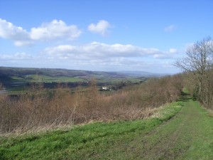
View across the Teme Valley to the Bromyard Plateau and the Clee Hills (north), from Pudford Hill ridgeline
Geological Overview
The ridgeline rises out of the otherwise gently rolling landscape, is made up of rocks that are around 420 million years old, formed during the Silurian period. Precambrian rocks, such as those in the Malvern Hills are overlain by folded and faulted shale and limestone. These rocks were uplifted, along a line of weakness in the Earth’s crust, during a mountain building event between 360 and 250 million years ago. Since they were uplifted, the limestones have withstood the ravages of erosion over time to eventually remain standing proud of the surrounding landscape because they are much harder.
The individual hills are offset from each other, rather than one continuos ridge due to the cluster of faultlines in the area. Movemnet along these faults have displaced the hard limestone.
The high vantage point afforded to the ridgeline gives rise to spectacular views across the surrounding landscapes. The ridgeline divides the Palaeozoic rocks to the west from the Mesozoic rocks to the east. This divide gives rise to variable landscapes due to the dfferent underlying rock types present either side of the divide and due to the significant difference between the number of earth movements each has experienced over their geological history.
Location
Shelsleys & Martley, Worcestershire; Grid Reference: SO 7429 6604 (north) – SO 7468 6091 (south)
Access
Open along public right of way
Geological Age
Silurian
Features
Views of landscapes and landforms
Teme Valley, Bromyard Plateau, Clee Hills, Worcester Basin, Malvern Hill
Ridge and vale topography
Geomorphology
Geological history setting
Structural geology
Interpretation
Interpretation boards on the ridge
Martley Geology Trail 1
Martley Geology Trail 3
Section 7 of the Geopark Way trail


