Geology map

Geological Map of the Abberley and Malvern Hills Geopark

AMHG British Geological Survey Map

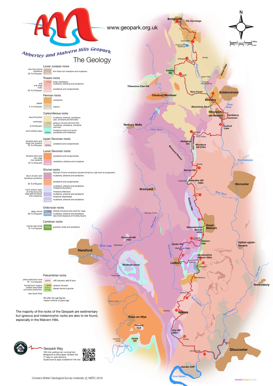
The Abberley and Malvern Hills Geopark Geology map is a ‘Special Edition’ map, which is purpose-made by the British Geological Survey.

The main map is a simplified geological map covering the 1250 squared km extent of the Geopark spanning parts of the four counties; Shropshire, Worcestershire, Herefordshire and Gloucestershire, in a strip of countryside that is at most 18km wide and 83km long.

Drawn at 1: 100 000 scale, this map is accompanied by a detailed key and generalised vertical section that gives information about the rock units found within the Geopark. In addition, the map sheet includes a detailed insert map of the area immediately around the line of the Abberley and Malvern Hills ridges – plus two cross sections taken along key lines within the Geopark.

The map is folded to A5 in size. Unfolded the dimensions are 1m x 70cm.

The map, sold in a clear plastic pocket, is available from Herefordshire and Worcestershire Earth Heritage Trust. Cost £6.00 plus p+p. To purchase online click here or call 01905 855184.

To buy a Geopark Way Trail Guide together with a Geopark Map, presented in a clear plastic protective sleeve click here . Cost £15.00 plus p+p.

British Geological Survey Publications

The British Geological Survey (BGS) publishes geological maps and memoirs of districts across the British Isles.

Memoirs contain detailed information on the structure, stratigraphy, and palaeontology, and many have sections on mineral resources, geohazards, groundwater and geophysics of the district. They are well illustrated with diagrams, sections, photographs and contain extensive references and bibliographies.

Geological maps show the nature, extent and relative stratigraphical age of the different rocks within a district.

British Geological publications relevant to the Abberley and Malvern Hills Geopark:

Memoirs

  • Geology of the country between Dudley and Bridgnorth: T.H.Whitehead, 1947
  • Geology of the country around Droitwich, Abberley and Kidderminster: G.H Mitchell et al, 1962
  • Geology of the country around Worcester: W.J. Barclay et al, 1997
  • Geology of the country around Tewkesbury: B C Worssam et al, 1989

Geological Maps at 1:50 000 scale

  • E167 Dudley
  • E181 Ludlow
  • E182 Droitwich
  • E199 Worcester
  • E216 Tewkesbury
  • E234 Gloucester

A guide to the Geology of Martley

Graphic1

Teme Valley Geological Society publication

An audit of Martley’s geological features was carried out in 2012 by the Teme Valley Geological Society. The audit forms the basis of this A4 book. The guide includes a  comprehensive introduction to the geological history of Martley over the last 700 million years and contains survey details of key sites with pictures.

For further details please contact the Teme Valley Geological Society secretary:

If you are interested, please contact the Society: martleypfo@gmail.com

www.geo-village.eu

Exploring Aggregates along the Geopark Way

Exploring Aggregates along the Geopark Way booklet

Exploring Aggregates along the Geopark Way booklet

The ‘Exploring Aggregates along the Geopark Way’ booklet takes a look at the aggregates industry as a whole, before exploring the aggregates industry within the Abberley and Malvern Hills Geopark.  The booklet was funded through the Aggregates Levy Sustainability Fund.

The first third of the booklet explores the facts and figures of the aggregates industry on a global and U.K level looking into the positive and negative elements of the industry. The remainder of the booklet concentrates on the aggregates industry within the Geopark (most of which is historical rather than current). After an overview of this history, the booklet then details nine former aggregate sites located either on or in close proximity to the Geopark Way walking trail. These nine sites reflect the diversity in geology, size, age and post-extraction use of the aggregate quarries found along the Geopark Way trail.

The nine sites are:

  • Eardington Sand and Gravel Pits
  • Raggits Hill Quarry
  • Callow Hill Quarry
  • Hartlebury Common Gravel Pits
  • Penny Hill Quarry
  • Martley Pit
  • Whitmans Hill Quarry
  • Malvern Hills quarries/Chase End Quarry
  • Huntley Quarry

Each site in the booklet gives an overview of the geology followed with details on the quarrying history at the site and the post extraction/current use of the former quarry site.

To download a copy of the booklet click here.