Malvern Hills GeoCentre

logo MHGC


Description

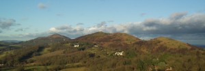
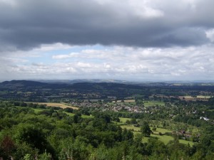
The Malvern Hills GeoCentre, situated on the western slopes of the Malvern Hills about a hundred meters from the Wyche Cutting is half way along the Geopark Way long distance walking trail.  As the trail descends from the Hills at the Cutting, it passes along Walwyn Road towards Colwall, and the Malvern Hills GeoCentre is located on the right hand side as one makes the initial descent.  From the car park, there is often a stunning view across Herefordshire towards Hay Bluff and the Black Mountains on the Welsh border.

The GeoCentre is part of the Wyche Innovation Centre, a business and technology facility serving entrepreneurs and start-ups in the Malvern area.  The GeoCentre was officially opened in June 2013 by Chris Darmon as part of GeoFest and is the official visitor information centre for the Geopark Way.

The Centre makes use of modern technology to disseminate a wealth of information about the Malvern Hills, the associated Area of Outstanding Natural Beauty, and the enlarged area of the Geopark.  Information is available on iPads housed.  The content includes information on the local history, geology, hydrology, flora and fauna, and technology heritage.  The information is arranged in a web-based format, enabling new information to be added with ease, and allowing the curators to research which pages are of most interest to visitors and hence optimise the content for the future.

In addition to the iPads, a large video wall projects images, videos and information about the Geopark and local area.  These include a set of stunning images compiled by Mike Brooks (BrooksDesigns) that were taken to populate his geological-focused walking tour Apps along the Geopark Way.

The wall maps at the Centre include QR Codes and Near Field Communication (NFC) chips to enable smart phone users to obtain more information about the maps on their own device.  This means less information has to be printed on the wall displays, and updating the information by digital means is quicker and less costly.  The information is also integrated with the iPad content, so both mediums can be used.

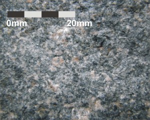
Despite the limited space, the Centre has some traditional exhibits of rocks and fossils from the local region.  These help to bring the local geology to life.  For those wanting more information, a range of printed guides, books, and leaflets are also on sale, including those from the range of Geopark Way publications.

Several events are run and/or hosted at the Malvern Hills GeoCentre.

Café H2O

Finally, the Centre offers refreshments from Café H2O; light meals, Teapigs tea, coffee, hot chocolate, Clive’s Fruit Farm fruit juice, Holywell Spring Water, filled rolls, toast, soup, jacket potatoes, salads, snacks, cakes and Bennett’s Farm ice cream.  Many of the items on the menu are sourced locally, such as the fruit juices, crisps and ice-creams, and the sandwiches, salads and cakes are all prepared by the café operators Team Jamboree.  This venture is also unusual, as Team Jamboree are a co-operative of adults each with a learning difficulty, managed by Kate Harding and Debbie Probert.  The café provides an opportunity for the individuals to plan activities, prepare food, and serve customers.  As a result, the cooperative members share in the profits and success of the social enterprise as well.

Geology and Landscape

The Malvern Hills ridgeline

The Malvern Hills ridgeline

The rocks of the Malvern Hills consist of igneous and metamorphic rocks collectively referred to as the Malverns Complex. They formed about 680 million years ago. Travel back in time to the Precambrian and the position and shape of the continents was completely different from today. This area was located some 60° south of the equator on the northern edge of an ancient supercontinent called Gondwana. The collision of two tectonic plates at the edge of this landmass resulted in one of the plates sliding under the other along a line known as a subduction zone. The intense heat and pressure caused by the movement of the slowly descending plate led to the formation of most of the igneous and metamorphic rocks seen on the Malvern Hills today.

Diorite

Diorite

The dominant igneous rocks on the Malvern Hills are dark green-speckled diorite; made up mainly of feldspar and the ferro-magnesian minerals biotite and hornblende, and plutonic pink granite; its components of quartz and feldspar giving the rock a pink colour. Later episodes of plate tectonic activity led to further bodies of magma forming, which were forced into cracks in the pre-existing Malvern rock. This magma then cooled and solidified, forming bodies (sills, dykes and veins) of dark-coloured igneous rocks called microdiorite and pink-coloured igneous rocks called pegmatite. In addition, the Malverns Complex suite of rocks include minor amounts of amphibolite (a dark green ultrabasic rock consisting entirely of hornblende) and the metamorphic rocks gneiss and schist. Gneiss is formed by extreme heat and pressure acting on pre-existing rocks. The minerals within gneiss are arranged in light and dark bands. Schist readily splits into flakes or slabs often with the mineral mica present.

Also found in the Malverns Hills are some ancient volcanic rocks known as the Warren House Formation. They comprise a suite of spilitic basalts (lava), rhyolites (lava) and ignimbrites (pyroclastic rocks). The eruption of these lavas has been dated at 566 million years ago, 100 million years after the formation of the Malverns Complex. The presence of ‘pyroclastic’ rocks (meaning ‘fire’ and ‘broken’) shows that these volcanic eruptions were extremely violent. These rocks can be seen on Tinker’s Hill, Broad Down and on Hangman’s Hill.

The ridge and vale topography to the west of the Malvern Hills

The ridge and vale topography to the west of the Malvern Hills

The younger Silurian rocks (438 – 416 million years ago) lie immediately to the west of the Malvern Hill ridgeline. This suite of varying sedimentray rocks all formed in a

marine environment. At the beginning of Silurian times sea levels rose with the melting of ice at the end of the Ordovician Ice Age. During early Silurian times the Malverns formed the eastern shoreline of the Welsh Sea. Some of the material eroded from the landmass to the east (the Midlands Platform) was transported west by streams to the nearby shore. This sediment over millions of years turned into siltstones, sandstones, breccias and conglomerates. Later during Silurian, limestones, mudstones and siltstones were deposited in the Silurian sea. Many of these rocks contain fossils.

Explore the Geology and Landscape around the Malvern Hills GeoCentre

Explore the bedrock and superficial geology of the area around the Malvern Hills GeoCentre on the British Geological Surveys ‘Geology of Britain Viewer’ – click here to be directed to their webpage

Facilities

  • Local information about the geology, history and wildlife of the area
  • Cafe (disabled access)
  • Toilets
  • Baby changing facilities and highchairs
  • Disabled toilets
  • Parking (for the cafe)
  • WiFi
  • Events
  • Gift shop selling local trail guides including the Geopark Way long distance walking trail guide book
  • A 22kW 32A Type 2 electric vehicle charging point*
  • Community defibrillator**
  • Great location for a refreshments stop whilst walking the Hills and/or local area
  • Ideal location to start your visit – pick up local walking guides, discover information about the area before you set off.  The centre is in close proximity to two carparks used for those walking the hills and local area

* A 22kW 32A Type 2 electric vehicle charging point is available in the car park, and subject to availability, its free to use whilst visiting the Malvern Hills GeoCentre . You can phone ahead if you’d like more information or to reserve it from an estimated time of arrival.

** A community defibrillator is available 24 hours a day in a secure cabinet in the Centre car park.  The key code for the cabinet is obtained by dialling 999 or asking at the Cafe during opening hours.

Opening times

Open Daily (except Wednesdays)*      9:30am to 4.30pm

*The Centre is generally closed to the public on Wednesdays, but are open weekends and Bank Holidays as usual. Contact the Malvern Hills GeoCentre to check.

Malvern Hills GeoCentre Photo Gallery

Contact details