
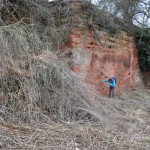
Lavingtons Cave, Bridgnorth
The Geopark is rich in both buried and visible archaeology, from the Neolithic period onwards.
Settlement was attracted to the well drained gravels of the river Severn terrace from the Bronze Age (1000BC). By contract the sculpting of the Malvern Hills themselves to create Late Bronze Age/Iron Age hillforts of Midsummer Hill and British Camp, and the boundary of Shire Ditch remain one of the most obvious symbols of the area – controlling territory on both sides of the Malvern ridge. Here the outlines of house platforms are still visible within the bounds of the substantial defensive earthworks. At Stourport–on-Severn, the geology was used in a direct fashion to carve rock dwelling out of sandstone during the medieval period.
As well as rich archaeology the Geopark is blessed with a significant industrial and mining heritage. The extractive industries that have developed in the Geopark are considerable, reflecting the geological variation of the area. Many of these industries have now ceased but have left behind a rich landscape and heritage.

Miners Memerial in Severn Valley Country Park, Highley
Coal and Iron
The Wyre forest Coalfield (WFC) forming the northern part of the Geopark has a history stretching back many centuries. Mining ceased in 1972 but much evidence still remains in what is predominantly an area of forest and agriculture
The coal measures are found in two distinct basins; in the north centred around Highley and Billingsley and in the south around Mamble, Pensaz and Abberley. In the main southern area three seams were worked; the Old Hall Bats, the Main Coal and the Hard Mine (Upper Coal measures). In the northern part of the coalfield these seams are underlain by the Productive Coal Measures. Four workable seams of coal and two ironstones are found; the most important coal seam was the Brooch.
There is evidence of mining in the WFC from medieval times and this continues until 1972 with the closure of the Hunthouse Colliery. Production probably increased until the early 19 th century after which it fell back, largely because of the difficulties of transporting coal away. However, with the coming of the railways, the fortune of the coalfield revived and it flourished in the first half of the 20 th century. The largest mine was at Alveley, which employed over 1000 men and drew in excess of 300,000 tones of coal a year in the late 1950s. It closed in1969.
Unlike many larger coalfields, there was no systematic attempt to restore former mining sites after extraction ceased. Thus much mining archaeology remains undisturbed in belts of woodland or on derelict land. In the vicinity of Billingsley, the productive coal measure outcrops are marked by numerous shallow workings in both coal and ironstone seams. The earliest of these probably relate to water powered blommeries close to the workings, where the ironstone would have been smelted. Pottery associated with these bloomeries suggests they were worked in the 13 th and 14 th centuries. Later ironstone workings here were associated with the 16 th century blast furnace at Cleobury Park, one of the first built outside of the Weald.
Further significant mining remains can be found in Kinlet, Chorley, Upper Arley, Bucket Leasow Colliery, Mamble and Hunthouse Wood.
In the south of the Geopark is the Newent coalfield. The mines of Newent and district were small compared to the neighbouring Forest of Dean. Mining in the Newent Coalfield extended from Blousdon in the south to Dymock in the north along a sliver of coal bearing strata bought to the surface by faulting. Around Hill End an inclined shaft (or dipple) was at work in 1860s. It is said that over a couple of months one man raised over 500 tons of ore, which went by canal to Wales. This shaft was used both as a coal and iron mine.
The Nubbins Quarry, Martley is the likely source of stone for St Peter’s church
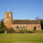
St Peter’s Church, Martley
Quarrying
Local quarrying is reflected in the construction of medieval and later buildings; particularly churches that run throughout the area. These include numerous nationally important Grade I or II* buildings. A study of the source of the building stones for such buildings illustrates patterns of medieval transport.
From the early 16th century, a new quarrying industry developed on a large scale with the extensive use of brick as a building material. This can be particularly seen in the post medieval buildings in towns such as Malvern, Bewdley and Stourport-on-Severn. The clay was extracted locally, with evidence surviving as scatters of brick pits
Along with being a source of building stone, locally quarried rocks served other purposes. Limestones fed limekilns in the production of lime; igneous rocks were principally worked for roadstone; ganister and fire-clays in furnace construction; sandstone as grindstones, rubble and road material; Clay in the pottery industry; and finally unconsolidated sand and gravel as aggregate and a constituent of construction material.
Archaeology and Industrial Heritage Image Gallery
