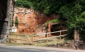
The Holding Pens
The rocks seen around Bewdley formed between 316 and 250 million years ago. These times equate to the older Carboniferous and younger Permo-Triassic Periods.
During Carboniferous times (359 – 299 million years ago) Britain was located close to the equator. Throughout this period the world’s continents were drifting together, forming an ever-increasing landmass. The earliest rocks from this period formed within an ancient ocean. As the continents continued to move closer together, this ocean disappeared and was replaced by tropical rainforests and giant swamps. Rivers brought material down from surrounding mountains and giant insects and ferns thrived. As these organisms died, their remains fell into the swamps, forming layer upon layer of organic material. Over time, these layers were squashed together, eventually forming coal seams. In between these seams, layers of mudstone and sandstone formed from sediment laid down by rivers. It is rocks from the latter terrestrial environment that can be seen and underlay parts of Bewdley Town.
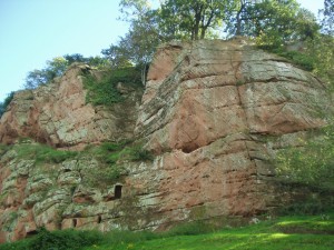
Blackstone Rock, Bewdley
During the 100 million years of Permo-Triassic times (299 to 199 million years ago),most of the world’s continents had joined together, forming a ’supercontinent‘ called Pangaea. Britain was located some 20° north of the equator, in the middle of this huge continent. Changing environmental conditions prevailed throughout these times; from ancient deserts to flat, arid landscapes covered in seasonal rivers and lakes. The presence of iron oxide in the rocks that formed during this time has resulted in them being predominantly red in colour and has led to the informal name ‘New Red Sandstone’. The distinctive colour of these New Red Sandstones can be seen in the River Cliffs around Bewdley and numerous road cuttings.
Along with the Bewdley ‘bedrock’, the ‘Building Stones’ of Bewdley’s buildings and structures tell a compelling story, one which is intrinsically linked to the history and transport history of the Town.
Explore the Geology and Landscape in and around Bewdley Museum
- A Museum Geology Trail – Bewdlwy Museum. Leaflet available from the Museum and as a download.
- The Geopark Way long distance walking trail passes through Bewdley. Section 4 of the trail guide Kinlet to Bewdley and Section 5 Bewdley to Larford Lake. Trail guide available from Bewdley Tourist Infomation Centre housed in Bewdley Museum.
- Sections 4 and 5 of the Geopark Way also available as Apps. The app has a map of the section overlain on an interactive geology map. Using GPS you get your position and a feed of data about the geology and other information as you walk. Other information’ includes photos of the walk with directional guidance, 3D cross-sections, and interpretations of past environments.Created by BrooksDesigns.
- Other geology and landscape trails in the area are:
- ‘Explore’ Bewdley Town – Building Stones – available from Bewdley Tourist Information Centre
- Bewdley Geology ‘Champions’ trail and booklet – available from Bewdley Tourist Information Centre
Explore the bedrock and superficial geology of the Severn Valley Country Park area on the British Geological Surveys ‘Geology of Britain Viewer’ – click here to be directed to their webpage
