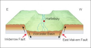
Diagram of the Worcester Basin
Hartlebury Museum and much of Hartlebruy parish sits upon Triassic- aged sandstone, specifically the unit of rock known as the Bromsgrove Sandstone Formation which is approximately 237 to 251 million years old.
If it were possible to travel back in to the Triassic perioid both the landscape and environment would be differ greatly to that of today. During the preceding geological period, the Permian (299-251 million years ago), a great rift valley formed due to movement along two almost parallel fault line; the East Malvern Fault and the Inkberrow Fault. A flat-topped prism of rock was created between the two faults which slowly fell by about 300om to form a rift valley, the Worcester Basin. During the Permian and Triassic times the basin began to fill with erosion products.
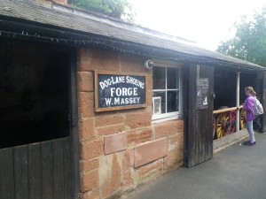
Triassic sandstone used as a building stone in Hartlebury Museum
The distinctly red coloured Bromsgrove Sandstone of Hartlebury formed from rivers flowing through the Worcester Basin depositing mainly sand and gravel material in channels to form river terrace deposits.
Explore the Geology and Landscape of Worcestershire County Museum at Hartlebury Castle
- A Geology Trail at the County Museum – leaflet available from the museum and as a download.
- The Geopark Way long distance walking trail passes close to the museum. through Severn Valley Country Park. Section 5 of the trail guide Bewdley to Larford Lake. Why not combine a walk along the trail with a visit to the museum. Trail guide available from the Vmuseum shop.
- Section 5 of the Geopark Way also available as an App. The app has a map of the section overlain on an interactive geology map. Using GPS you get your position and a feed of data about the geology and other information as you walk. Other information’ includes photos of the walk with directional guidance, 3D cross-sections, and interpretations of past environments.Created by BrooksDesigns
Explore the bedrock and superficial geology of the Severn Valley Country Park area on the British Geological Surveys ‘Geology of Britain Viewer’ – click here to be directed to their webpage
