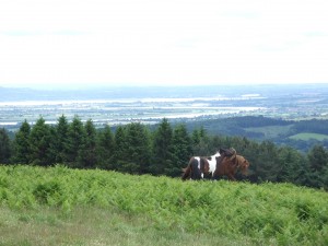
View from May Hill to the horseshoe bend of the River Severn – the southern most extent of the Geopark
Geological overview
May Hill is the most conspicuous landscape feature in the southern part of the Abberley and Malvern Hills Geopark and the views from the top are spectacular in all directions. The striking differences in landscape produced by the diverse underlying geology can be clearly seen in the contrast between the hilly uplands, produced by the older Palaeozoic rocks to the west, and the flat plain of the Severn Vale to the east, formed by softer Mesozoic sediments. Even on the hill itself there are minor variations in relief caused by the diversity of Silurian rocks outcropping. These range from hard limestones to soft sandstones and siltstones and contain a varied assemblage of characteristic Silurian fossils.
The underlying structure of the area is that of a NE trending pericline, truncated by faulting in the north and south, and bounded by more faults to the west and east; the eastern fault being an extension of the major East Malvern Fault that separates the Palaeozoic rocks from the Mesozoic sediments of the Vale. Within these faults, the rocks are folded into a dome, which has been eroded, leaving the oldest rocks exposed in the centre of the dome – the May Hill inlier.
Location
May Hill, Gloucestershire; Grid Reference: SO 6955 2133
Access
Open along public rights of way
Geological Age
Silurian – May Hill Sandstone Group
Features
From the top of the inlier of May Hill views stretch in all directions towards landscapes underlain by rocks of various ages
Interpretation
Section 15 of the Geopark Way trail
May Hill ‘uncovered’ – geology and landscape trail
