River Teme, Martley
Geological Overview
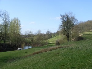
The River Teme is remarkable for its near natural form and as such is a Site of Special Scientific Interest (SSSI) throughout its length. Known as the ‘Wild Daughter of the River Severn’ due to its sinuous nature, it twists its way for 81 miles from its source on Cilfaesty Hill, Powys, Wales, through its often steep-sided valley to its confluence with the River Severn near Worcester.
The history of the River Teme is complicated and encompasses glacial diversions, river captures, glacial lakes, melt-water torrents and bygone river systems.
Today the Lower Teme has a deep channel cut in a wide alluvial plain. Channel plan-form is one dominated by free menders across the floodplain. Since the Teme is a ‘flashy’ river, which responds rapidly to rain fall inputs to the basin, large and rapid changes in stage, velocity and discharge occur. Thus form-process relationships at the channel margins are readily observable and often spectacular in nature. Channel change can be rapid. Cut-offs and near cut-off are numerous along the river’s course and floodplain features such as backchannels and old oxbows can be seen clearly.
Location
Teme Valley, Martley, Worcestershire; Grid Reference: SO 7450 6030
Access
Open along public right of way
Geological Age
Quaternary
Features
Geomorphology
Ice Age interpretation of the changing course of the River Teme
Interpretation
Interpretation board on site
Martley geology trails 1 and 3
Section 7 of the Geopark Way
