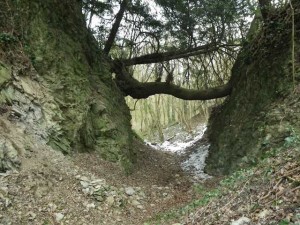
The Canyon, near Penny Hill Quarry
Geological Overview
The rocks exposed in the Canyon formed during the Silurian period (416-444 million years ago). Back then, the layout of the oceans and continents across the Earth looked very different. The land which would eventually form this part of Britain was located in the southern tropics on a continental shelf, blanketed in a warm, shallow, tropical sea. Carbonate productivity was extremely high in the warm Silurian sea, resulting in sequences of limestones and small patch reefs (bioherms). Pulverised shell debris and crinoid fragments within the limestone layers suggest the Silurian shoreline was prone to occasional heavy storms and vigorous wave action. By the Silurian a great number of sea creatures had evolved hard external skeletons – trilobites, corals, crinoids, brachiopods and mollusca. At times the floor of the tropical sea was, in areas, a waving meadow of generation upon generation of crinoids.
The layers of limestone in the Canyon face are all tilted from the horizontal. This is as a result of a long-lived deformational episode of mountain formation after the rocks were formed – an episode referred to as the Variscan Orogeny. The stresses and strains placed on the once horizontal layers of rock during this episode caused them to uplift, fold and in places be ripped apart along fault lines. Some of the phases of this episode were regional others very localised. By looking at the structures within the rock face it is possible to work the relative ages of the large scale and the very localised deformation phases that this unit of rock has been subjected to.
Location
Martley, Worcestershire; Grid Reference: SO 7526 6176
Access
Open
Geological Age
Silurian – Much Wenlock Limestone Formation
Rock Types
Sedimentary – limestone; shale; bentonite
Features
Fossils
Volcanic ash (bentonite) layers
Faults
Folds
Area structural geology setting
Interpretation
Interpretation board on site
Martley geology trails 1 and 3
Section 7 of the Geopark Way


