Leigh Brook, Knapp and Papermill Nature Reserve
Geological overview
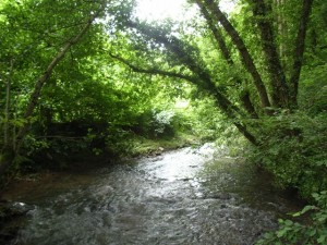
The Leigh Brook flows through the centre of a steep sided gorge in the Knapp and Papermill Nature Reserve. From its source to the south the brook follows relatively low ground, but here it suddenly enters the high ground formed by the hard Silurian rocks before emerging onto the Severn Plain. The valley through the hills is narrow and meanders on a scale fitting a much larger river.
It is believed that before the Ice Age, and before the soft rocks in the surrounding countryside were so greatly eroded away, a large river flowed along this course but on a wide plain at an altitude close to that of the present hill peaks. Some evidence for this rests in the small patches of river gravels found high on the adjacent hills.
During the Anglian Ice Age (500,000 years ago) this area was at the edge of a large ice sheet. As this ice melted, large quantities of melt water gushed down the river and cut a valley through the Silurian rocks to create the gorgewe see today.
Location
Alfrick, Worcestershire; Grid Reference: SO 7491 5170
Access
Open along public rights of way
Geological Age
Quaternary
Features
Fluvial processes
Classic riffle and pool morphology
Gravel bars and mid-channel islands
The brook is one of a rare number of watercourses that cross the Malvern Hills watershed
Geomorphology
Nature Reserve (Worcestershire Wildlife Trust)
Interpretation
Section 9 of the Geopark Way trail
Alfrick and the Suckley Hills’ geology and landscape trail
