Lavingtons Cave, Bridgnorth
Geological overview
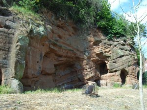
These rocks represent fossilised sand dunes and were part of a vast desert that existed around 299 million years ago.
During Permian times the Geopark sat landlocked 20 degrees north of the equator on a single continent known as Pangea. This had formed from a drifting together of all the previous continental plates of the earth’s crust. The wind was blowing sand dunes across a vast Sahara-like desert whilst occasional flash floods deposited alluvial fans.
Close inspection of a typical Bridgnorth Sandstone shows the grains of sand within are well rounded and polished by abrasion as they bounced against each other across the desert surface. The sand is dyed red by iron oxide which weakly cements the grains of quartz together.
Bridgnorth town was under siege in 1646, during the Civil War and a Colonel Lavington had forces dig tunnels towards the church, where St. Mary’s stands and where Royalist explosives were stored. He intended to blow up the church, but the event never took place, after excavating a tunnel 70 feet long, the castle surrendered and the digging stopped. The caves have been used as habitations since they were formed.
Location
Bridgnorth, Shropshire; Grid Reference: SO 7176 9282
Access
Open
Geological Age
Permian – Bridgnorth Sandstone Formation
Rock Types
Sedimentary – sandstone
Features
Sedimentary structures
Social history
Interpretation
Section 1 of the Geopark Way trail
Bridgnorth – Rocks beneath your feet (a ‘Walks For Health’ Leaflet)
