Highley and Alveley form part of the Wyre Forest Coalfield, an area covering 50 square kms. Since medieval times the various rock types making up the coalfield have been mined and extracted contributing both to the economy and character of the area.
Highley Colliery was established in 1878/9 by the Highley Mining Company, HMCo, and stayed open until 1969. The coal seam being mined lay at a depth of 300yds and was 4ft thick. Initially it would have been worked by hand under the light of the candle, production relying solely on the strength and skill of the miners. By the 1930s HMCo had deployed the use of mechanical cutters and a mechanised underground haulage system.
Coal comes in a variety of grades, the quality being dependant on the environment and conditions under which it formed. Highley Colliery coal was of a high grade so was sold for household use.
The Formation of Coal
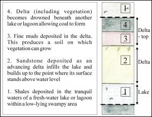
Cyclothem diagram
Coal is a sedimentary rock formed from the remains of trees and vegetation and requires specific conditions for its formation:-
- There must be plenty of vegetation living (and dying) nearby
- The dead plant material must accumulate in a swampy environment lacking in oxygen (this is to prevent the breakdown of the dead vegetation into soil).
- The accumulated vegetation must be sealed in by sediment above, such as sand or clay
- The vegetation has to be deeply buried. It is the heat and compression imposed by deep burial that brings about the formation of coal
Coal typically forms in a delta environment. This dynamic environment produces the sequence of rock types associated with coal formation, known as a Cyclothem.
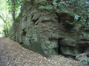
Carboniferous sandstone exposed along a footpath (former tramway) in SVCP
It was 345 million years ago, during the period of time known geologically as the Carboniferous that such conditions existed here in Britain. During the Carboniferous, the area now known as Highly was sitting astride the equator experiencing a warm and humid climate. Lush vegetation grew in the resultant swampy conditions.
Coal was not the only Carnoniferous rock from this area that has been extracted for commercial gain over the ages. Sandstone too has been quarried and used as building stone and tiles. The sandstone formed around 300 million years ago from sand particles that travelled from the south in rivers before being deposited in the delta. As the river entered into this larger mass of water its energy decreased forcing it to deposit the sand particles it was carrying. Over time great quantities of sand accumulated. This sand was then buried turning loose material into hard rock.
The River Severn
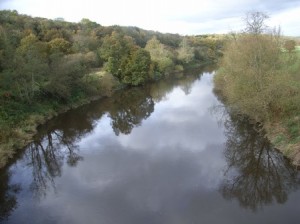
The River Severn running through the Country Park. In geological terms the river is a very recent addition having carved out its course over the last 12,000 years
It comes as a surprise to discover that a feature as large and important as the River Severn is so recent an addition to the Parks landscape. Before the final phase of the Ice Age the upper Severn flowed roughly north-east from its Mid-Wales source on Plynlimon to the sea near the present Dee estuary. The last glacial period, the Devensian, started around 30,000 years ago. An ice sheet travelled from the north and west across the Cheshire Plain and north Shropshire coming to rest against the higher ground of the south Shropshire hills. From the front of the ice sheet poured melt-water carrying silts, sands, gravels and pebbles which spread down the shallow valley (actually the headwaters of a tributary of the River Stour) to the south. Beneath the glacier large quantities of summer melt-water, laced with pebbles, scoured networks of channels into the underlying solid rock.
By 12,000 years ago the ice sheet had receded. The majority of the scoured channels became filled with sands and gravels. One in particular did not though and served as a main conduit for the large amounts of water flowing from the receding ice sheet in the area, cutting itself deeper and deeper. This channel became the world heritage site of Ironbridge Gorge, which lies 14 miles north of the Park. With the receding icesheet now blocking its old northerly course towards the Dee, the River Severn established a meandering easterly course through Shrewsbury and to the Ironbridge Gorge before turning south into the head-water valley of the the River Stour.
The lower terraces of the Severn are glacial valley train terraces. The power of the torrents which deposited the terrace gravels is illustrated by the size of some of the rock fragments carried. These can be boulders of more than one tonne in weight.
Explore the Geology and Landscape of Severn Valley Country Park
- Country Park Geology Trail (2 km/1.2 miles) – leaflet available from the Visitor Centre and as a download.
- The Geopark Way long distance walking trail passes through Severn Valley Country Park. Section 2 of the trail guide Dudmaston to Highley. Trail guide available from the Visitor Centre.
- Section 2 of the Geopark Way also available as an App. The app has a map of the section overlain on an interactive geology map. Using GPS you get your position and a feed of data about the geology and other information as you walk. Other information’ includes photos of the walk with directional guidance, 3D cross-sections, and interpretations of past environments.Created by BrooksDesigns
- Severn Valley trail: Bridgnorth to Highley The formation of the Severn Valley between Bridgnorth and Highley
- Alveley and Severn Valley Country Park trail – from coal pits to parkland. Free download
Explore the bedrock and superficial geology of the Severn Valley Country Park area on the British Geological Surveys ‘Geology of Britain Viewer’ – click here to be directed to their webpage
