Astley sunken lane
Geological Overview
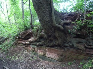
This sunken lane leads from Astley church down to Dick Brook and Newbridge Coppice. The track cuts down through several layers (beds) of red sandstone – a Triassic-aged rock which formed around 230 million years ago.
Many of the different layers of sandstone display varying sedimentary structures. Beds differ in thickness, some displaying no features, others are finely laminated, other are cross bedded.
With the diversity of sedimentary structures and grain sizes, some of them subtle, this sunken lane is a pleasing location to explore the environment in which the sediments were first deposited to later be formed into rock. What type of environment allows for this rapidly (in geological terms) changes in environment to create the sedimentary structures seen?
Location
Astley, Worcestershire; Grid Reference: SO 7890 6745
Access
Open, along public rights of way
Geological Age
Triassic – Bromsgrove Sandstone Formation
Rock Types
Sedimentary – Sandstone, siltstone, mudstone
Features
Variable grain-size
Sedimentary structures
Interpretation
Section 6 of the Geopark Way trail
