Leapgate Old Railway Line, Wilden Top
Geological overview
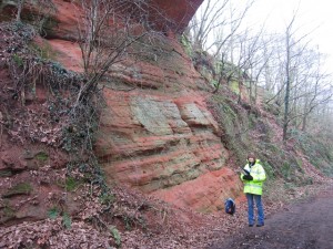
The ‘Old Railway Line’ cuts through the red sandstone bedrock. These sandstones are Triassic in age, belonging to the ‘Sherwood Sandstone Group’ of rocks.
The Sherwood Sandstone Group, the older Permian-aged Bridgnorth Sandstone and the younger Triassic-aged Mercia Mudstone Group have one thing in common; they were deposited in a vast rift basin, called the Worcester Basin.
The Worcester Basin was north-south orientated and formed during the Permian period. Its western edge, in the Geopark area, followed the line of a major fault-line, the East Malvern Fault. In the present day this fault line is most clearly marked by the Malvern, Suckley and Abberley Hills. The eastern edge of the Basin followed the line of another major fault-line, the Inkberrow Fault.
Into this basin a great variety of different sedimentary rocks were deposited and formed. Some were windblown deposits, others were despotised by streams and rivers, evaporate deposits also formed in lakes and the other significant deposit was alluvial fans that formed along the edge of the basin. Each of the rocks represents the changing environments experienced in the basin through the passage of time.
The rocks seen along the ‘Old Railway Line’ belong to the Wildmoor Sandstone Formation, part of the Sherwood Sandstone Group of rocks. They are around 220 million years ago and comprises soft, weakly cemented, pale red-brown, micaceous, sandstones. The well-rounded, evenly sized grains suggest reworking of windblown sands that were deposited the Worcester Basin during the Permian period.
Location
Stourport-on-Severn, Worcestershire; Grid Reference: SO 8269 7202
Access
Open
Geological Age
Triassic – Wildmoor Sandstone Formation
Rock Types
Sedimentary – sandstone, siltstone
Features
Sedimentary structures
Interpretation
Section 5 of the Geopark Way trail
